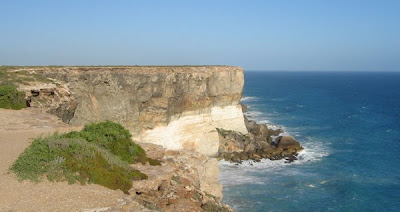
The cliffs at the Great Australian Bight. These magnificent cliffs run for hundreds of kilometres along the bottom edge of Australia. East of Eucla they are called the Bunda Cliffs; in the west, the Baxter Cliffs. Together they're apparently about 400km long.
I first saw them when I was twenty and have never forgotten it. Seeing them again was even better.

There is a section of the Nullarbor where the cliffs run inland, forming the edge of the Hampton Tableland; below it are the Roe Plains. This photo, taken at Madura Pass, looks out to the Roe Plains from up on the Tableland. Madura Pass is one of the highlights of the journey.

I wish I had taken a photo of the moonlit Nullarbor, achingly beautiful -- it makes you want to lie flat on your back on the ground and just stare at the sky.
There's a detailed book about the Nullarbor by Neville Collins, The Nullarbor Plain: A History, including many striking photographs. It surveys the region's Aboriginal history as well as colonial incursions, and has other sections covering everything from flora and fauna through UFO claims, hoaxes, space debris (Skylab fell near Balladonia, on the western edge of the Nullarbor, in 1979), to meteorite finds and nuclear testing. Collins was born at Ceduna in South Australia, to the east of the Plain.
No comments:
Post a Comment